Emily Lakdawalla • Jul 25, 2018
Liquid Water on Mars! Really for Real This Time (Probably)
A radar instrument on one of the oldest operational Mars orbiters has discovered possible evidence of present-day liquid water on Mars.
Liquid water on Mars? Again? Yes, again. The announcement came at a press briefing held by the Italian Space Agency in Rome, concerning a paper published today in Science.
How is today's water-on-Mars hoopla different from all of the past announcements? In brief: the evidence is from a new instrument, examining a new location on Mars, and it's the first place we've seen evidence for a present-day body of water that is liquid and stays liquid. For years.
Probably.

The report comes from the European Space Agency's Mars Express, the second-oldest spacecraft still operating at Mars. It's best known for the beautiful color stereo images from its High Resolution Stereo Camera, but today's results come from a different instrument, the Mars Advanced Radar for Subsurface and Ionosphere Sounding (MARSIS). To explain the water story, I'll need to explain the instrument.
MARSIS transmits radio waves at Mars using a pair of booms, each 20 meters long, which extend on each side of Mars Express. The radio waves bounce off of Mars, and MARSIS measures the time it takes for the waves to travel there and back. Naturally, MARSIS detects strong reflections from the planet’s surface.
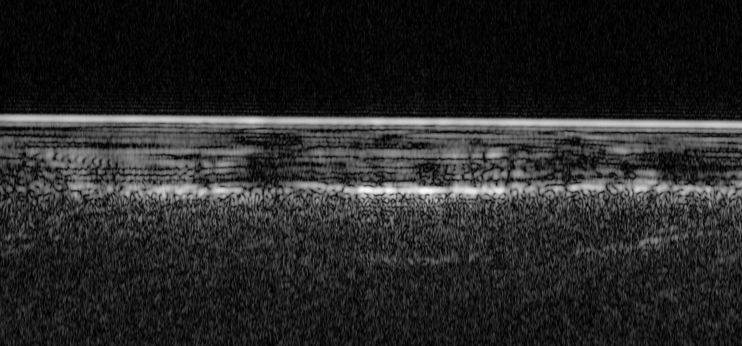
But the long radio waves from the 40-meter antenna can actually penetrate as many as 5 kilometers into the Martian surface and reflect off of interesting things below. Subsurface boundaries between layers of different properties — boundaries between rock and soil, or rock and ice, or clean ice and dusty ice — can also serve as radio reflectors. So MARSIS may detect multiple echoes from each radio pulse. It pulses many times along its ground track, building up a 2-dimensional view of the subsurface called a "radargram."
The bulk of MARSIS's results from Mars Express's 15 years at Mars have detailed the interior structure of the planet’s polar layered deposits. Both poles have these deposits, which consist largely of dusty water ice, in layers — they have a stripy appearance when viewed with cameras from orbit. MARSIS's radar sounding has traced those layers below the surface and mapped the sharp boundary of the base of the deposits at each pole, sensing the rocky surface of the planet buried beneath kilometers of ice. The MARSIS team first reported on their studies of Planum Australe — the south polar layered deposits — in 2008, noting that MARSIS could detect reflections from as much as 3,000 meters beneath the surface — very deep.

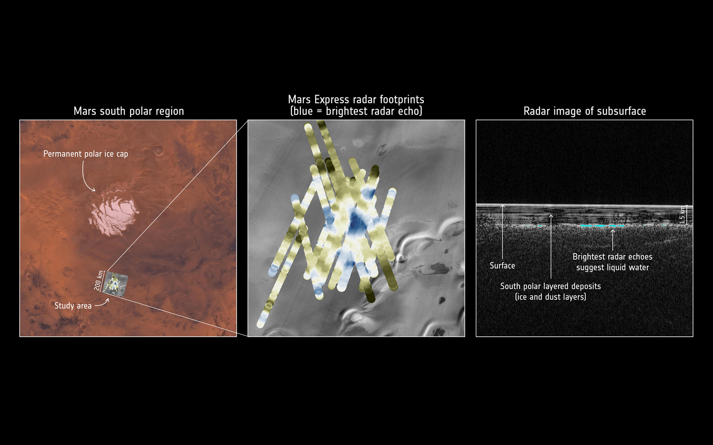
More recently, the MARSIS team picked a region where the surface appearance of the south polar layered deposits was especially bland, to try to study the base of the deposits in more detail. (If the surface is bland, it should be easier to see interesting things happening below.) MARSIS studied this region intensely from May 29, 2012, to December 27, 2015, collecting 29 crisscrossing radargrams.
In most places, the scientists described the bottom-most reflection on the radargrams as "weak and diffuse," but in a few places, they found it to be crisp and bright, indicating a very strong contrast between the layered deposits and whatever underlies them. In one particular location, about 20 kilometers wide, where many radargrams crossed, they kept hitting an especially strong and bright reflective boundary at about 1,500 meters beneath the surface.
An unusual, contained, 20-kilometer-wide spot of very strong radar contrast suggests an unusual material that is very different from the ice above it or the rock below it. It has consistently been detected over a period of three years. An unusual material located at the base of an ice sheet: Could it be a long-lived lake, like subglacial lakes on Earth?
Not so fast. The temperature is a challenge. It's pretty straightforward physics to predict the temperature at the base of the southern polar layered deposits. That predicted temperature is -68°C. Neither on Earth, nor on Mars, can water exist as a liquid at such a low temperature. Not without help, anyway.
But help for liquid water may exist down there. On Earth, sub-ice lakes exist at temperatures as low as -13°C. The freezing point of the water in lakes under ice in Antarctica is depressed by the presence of large amounts of salt (much more salt than is present in Earth's oceans). Mars has salts of sodium, magnesium, and calcium that — if concentrated enough — can depress the freezing point of water to as low as -74°C. Perchlorates — salts discovered by the Phoenix lander and observed also by Curiosity — are especially good at helping water remain liquid at cold temperatures. So it is physically possible that a very, very, very salty lake could exist beneath Mars' southern polar cap.

Okay, it's possible. But is it probable? The answer: yes! In fact, according to Roberto Orosei (National Institute of Astrophysics, Italy) and colleagues, a sub-ice briny lake (or layer of very sludgy, liquid-water-rich sediment) is the most likely explanation for this unusual reflective spot!! That's not quite strong enough evidence to constitute scientific proof for a hard-bitten, skeptical scientist such as myself, but if you'd like to imagine sending submersible spacecraft into an actual present-day sub-glacial liquid water lake on Mars, you have my blessing.
What can we do to confirm that such a lake exists? Higher-resolution data would help. MARSIS's radar spots span about 5 kilometers, so they barely resolve the 20-kilometer width of this putative lake. Future missions capable of better detail could more precisely map its contours and how they relate to the shape of the hidden rocky surface and the icy layers above.
If MARSIS has discovered a 20-kilometer-wide patch of liquid water, which is close to the limit of its detection resolution, there's every reason to believe there could be more such patches, too small for MARSIS to definitively resolve. If we get that higher-resolution view, it's possible we could discover lots and lots of briny spots deep underneath the Martian south polar cap.
Read the original Orosei et al. paper here and a companion "perspective" article by Anja Diez here.
Let’s Go Beyond The Horizon
Every success in space exploration is the result of the community of space enthusiasts, like you, who believe it is important. You can help usher in the next great era of space exploration with your gift today.
Donate Today

 Explore Worlds
 Find Life
 Defend Earth

