Deepak Dhingra • Oct 21, 2015
Preparing for the Journey to the Moon, Mars and Beyond
We've all had our moments of awe and wonder looking at the images from distant planetary bodies. Whether they were the first images of Titan’s surface from Huygens probe (on the Cassini mission), the hollows on Mercury (from the MESSENGER mission), the stunning imagery of Comet 67P (from Rosetta and Philae) or the bright spots on Ceres (from the Dawn mission), we continue to be amazed! Sometimes it is the remarkable similarity of an alien world to the terrestrial landscape (think about drainage channels on Mars and Titan), while on other occasions it is their bizarre nature or the geologic process involved (think about the glaciers on Pluto or the volcanically active Io). I think most of you would agree that such observations tend to raise more questions than answers. ;) Perhaps the best way to answer some of those questions and interpret observations of far-away worlds is to see the process (or product) taking shape in front of our own eyes—something that we call ground truthing in the remote sensing community. And what better place to experience the action than the natural landscape itself?
I had the opportunity to be part of a scientifically stimulating—at times challenging but fun—planetary analog field trip exploring a very young volcanic terrain in Idaho at Craters of the Moon (COTM) National Monument and Preserve. Huddled in the southeast corner of Idaho, COTM represents an extensive lava field spread over 1600 km2 and formed by more than 60 lava flows that erupted over a time period between 15,000 to as recent as 2000 years ago! On a geological time scale, that's just a few seconds ago. The eruptions were the result of volcanic activity along a rift (or large fracture) in the continental crust. COTM is currently dormant, but may be activated in another 1000 years or less based on the record of geological activity there.

A strong contingent of 35 people from all over the world descended upon COTM armed with a host of instrumentation, ranging from a rock hammer (no surprise, it is the most important tool of a field geologist!) to instruments that could measure mineralogy, chemistry, and surface topography. The investigations were further augmented by unmanned aerial vehicles (UAVs) with cameras to provide an aerial view of selected targets, as well as hyperspectral cameras on the ground to obtain high-resolution images of interesting targets in over 100 wavelength channels (to determine mineralogy). Many of the measurements were carried out in sync with each other in order to obtain an integrated dataset, which is critical for solid interpretation of the observations. The rich instrumentation capabilities of the group were matched with an equally interesting human resource that included, besides scientists, graduate and undergraduate students, high school students, school teachers, and a film crew. This field trip forms part of a multi-year effort supported by NASA under two projects: Field Investigations to Enable Solar System Exploration (FINESSE) and Biologic Analog Science Associated with Lava Terrains (BASALT).
The team divided itself into many small groups to carry out various scientific investigations in different parts of the lava terrain with the aim of fulfilling a couple of objectives:
1) Characterize the compositional and textural diversity of the enormous lava sea at COTM and use it as an analog (or reference) for better understanding of the vast regions of basaltic lava on the Moon.
An associated goal was to better comprehend the complexity of the lava deposits on the ground to enable more informed interpretation of satellite data (similar to COTM image from Landsat above) since in case of the Moon, we are largely restricted to observations from spacecraft.
2) Identify simple life forms (microbes/bacteria) that might currently be supported by these lava compositions, or may have been supported in the past during volcanic activity and associated hydrothermal processes.
3) Compare and contrast the scientific output of various techniques in the field to identify synergy and to optimize field operations when some of these (not all) instruments might be used during human or robotic exploration of the planetary bodies. We, in fact, had a specialist on our team who was studying the coordination between various instrument teams to better understand the interaction and possible ways to improve.
COTM hosts a diversity of lava flows ranging from smooth to rough to blocky that erupted from several small and large volcanic centers. Some of these eventually formed nested craters. The area also has lava tubes, similar to the lunar skylights, providing another area for analog studies. LIDAR (Light Detection And Ranging) measurements at one of the lava tubes allowed 3-dimensional re-construction of the cavity and the capability to analyze this interesting geologic structure from multiple perspectives. Such measurements are important since lava tubes have been suggested as possible habitats for future astronauts. The tubes could provide protection from the intense radiation environment on the airless Moon. The LIDAR observations, together with differential GPS (Global Positioning System) allowed the measurements of topographic variations as small as couple of centimeters.
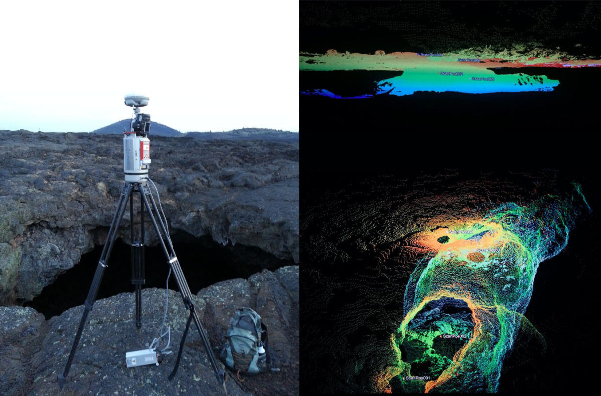
We carried out an extensive LIDAR survey over a lava flow that almost looked like a river but was made up of molten rock! The lava flow was located in a valley surrounded with steep crater walls made up of glassy, fragmented and fused material that was black at certain locations (due to abundant glass) but at other locations had different hues of red, yellow, white and orange colorations, perhaps the result of the extensive hydrothermal alteration that this material may have undergone. The lava flow was extensively fractured with giant collapse pits making it hard for the LIDAR instrument to be mounted in a stable position. The ropy texture in the lava (also known as "pahoehoe" in geological terms) was observed at a much larger scale than is commonly observed. If the river of molten rock was not sufficient, we also witnessed a cascading flow of molten rock spanning several meters, now frozen in time! The giant eruption probably inundated the surface at multiple topographic levels, where it cascaded and meandered before joining the mainstream. What a spectacular scene it would have been...
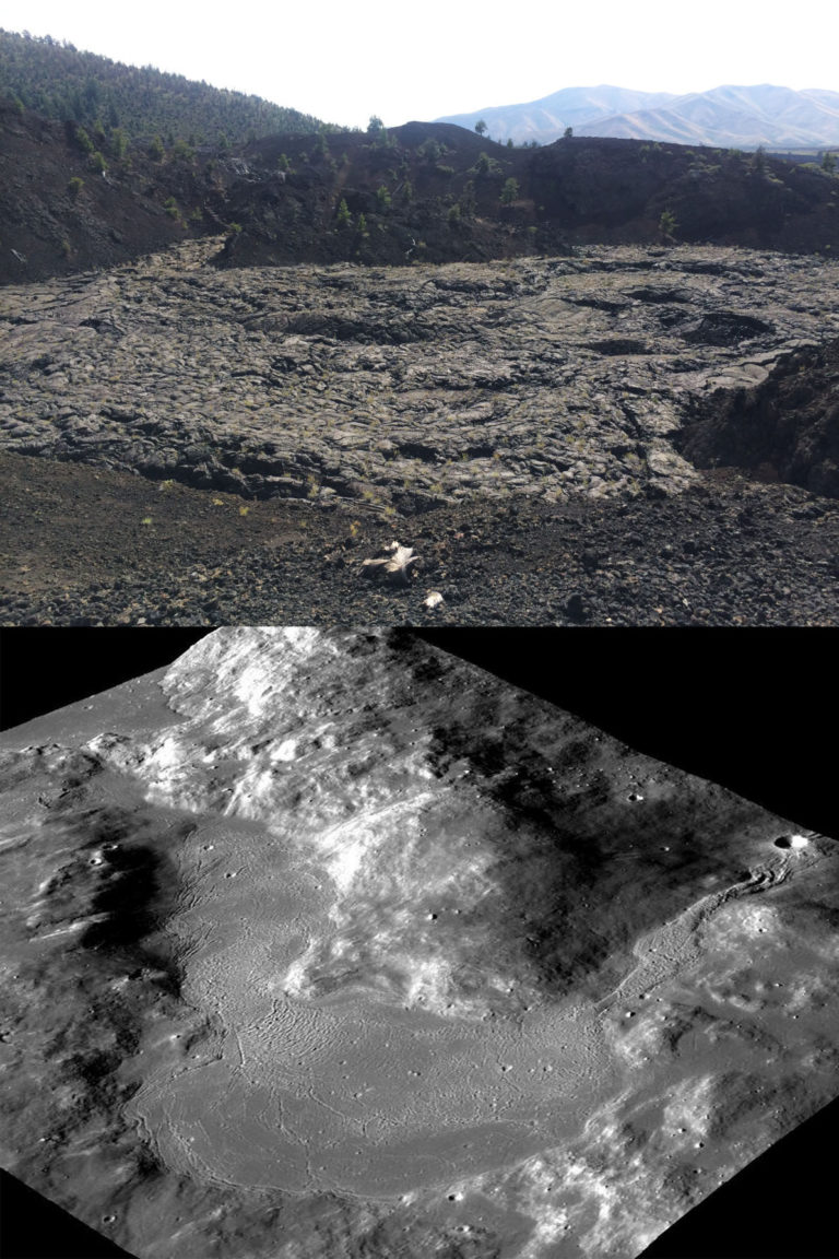
If you are wondering whether any of these seemingly interesting surface morphologies could also have implications for understanding the landforms on the Moon, you are in luck! I can think of at least two places on the Moon where similar landforms have been formed by molten rock (see comparison below). The only difference though is that the molten rock on the Moon, at the specific locations shown here, was not produced by volcanism, but rather due to meteorite impacts. This different origin for the landforms shown here makes it even more interesting to compare with the two landforms at COTM.

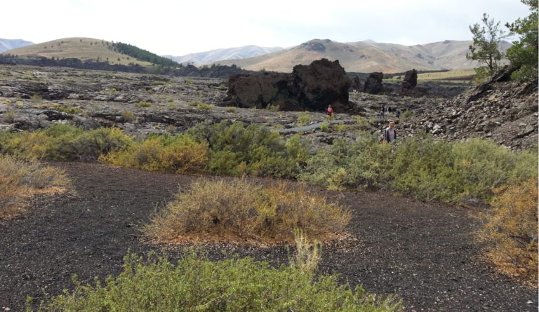
After finishing up our LIDAR survey at North crater flow, as we were walking back, we witnessed giant walls of rock resting on the lava flow, just like rafts in the sea! These giant blocks of rock represent broken-up fragments of the crater wall that were torn apart by the enormous energy of the eruptions. These isolated blocks were then transported to long distances on the flowing lava. Are there any parallels on the Moon (or Mars)?? I don’t know yet!
The composition of these lavas and their variability was another major task that we all spent time on. Some of us, loaded with sophisticated spectrometers, measured the reflected light from the rocks to determine their surface mineralogy while others gathered fresh rock chips, grounded them up to feed into instruments for obtaining the bulk mineralogy and chemistry. These measurements were supplemented with detailed notes on the sampling location, including descriptions of the rock. At the end of each such session, precious samples were collected for laboratory studies to further extend the analysis. The measurements described above were "point measurements"—measurements at a specific location. How about obtaining simultaneous information about each and every spot in a given scene? Going to each of the locations would be tough and inefficient. So, we also brought an imaging spectrometer to scan the entire scene, similar to taking photographs. The difference however was that it was taking several hundred photographs of the same area but across different wavelength channels. Once these images are stacked, each pixel in the image gives a spectrum that can be used to decipher mineralogy. These measurements were made to decipher mineralogy that could be associated with primitive forms of life. The measurements were accompanied by some sophisticated sampling where the rock samples were immediately transferred to frozen containers and shipped for laboratory analysis to study the presence of any life forms. This activity helped in fulfilling the Mars sample return analog goals.

One of the most challenging and tedious measurements was using the differential GPS (dGPS). The task involved straight line traverses on the lava flow holding a GPS mounted pole with the bottom in contact with the ground all the time. What it means is that irrespective of the terrain, whether it is a drop of several meters or a rise, one needs to keep following the terrain all along the traverse. Sometimes the traverse was a mile or more long! A small team of people aligned themselves along the traverse (marked by a line of cones) and used to gently pass the GPS pole from one hand to the other with the pole touching the ground—a seemingly simple activity, yet very tedious. At times we ran into unstable blocky flows, large bushes, or a steep fall. Throughout the measurements, we were also in contact with another GPS positioned far away at the base station. Using this configuration, the team was able to obtain surface profiles stretching over a couple of miles with measurements made every 15 centimeters. Surface roughness differences as small as few centimeters were measured in this way. This rich dataset will now be compared with lava flows on other planetary bodies to compare and contrast the surface roughness and decipher its implications.
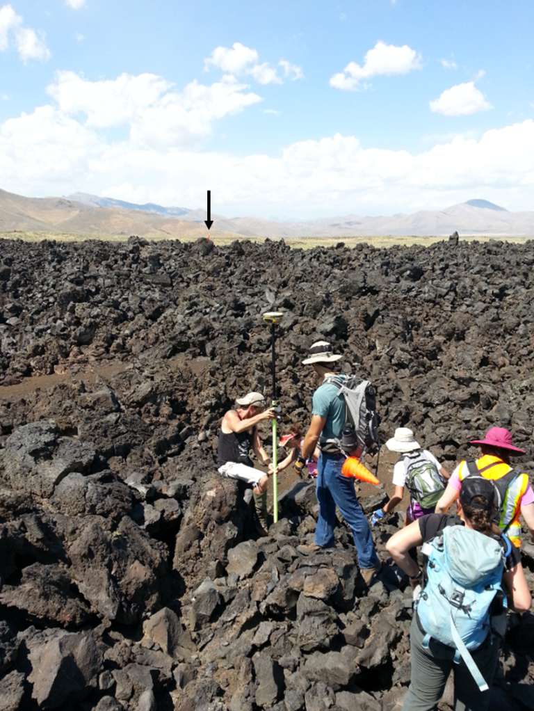
UAV-acquired imagery can also be used to obtain topographic details. Later analysis and comparison of acquired data has shown the UAV derived topography is just as good (sometimes better!) in terms of quality & resolution compared to the ground-based dGPS (tedious!) method—so this finding has important implications regarding the efficiency of collecting such data on the Moon & Mars. Another important lesson learned from the field studies!
No description of the COTM would be complete without the blue dragon flows. This was one of the fascinating observations and also the one that was most talked about among the team members. This particular lava flow has a shiny blue sheen, much like a coating. Although this observation is not new and has been talked about by several other people who have been to COTM, what makes it interesting is the fact that there does not seem to be a firm answer about its origin and why it is associated with a particular lava flow. Some people have ascribed it to the presence of titanium-bearing magnetite, but many questions remain. Hopefully we will get some answers to this mystery before we go back to the field next year in our endeavor to prepare for the journey to the Moon, Mars and beyond!
But before I sign off, here is the link to view some of the spectacular aerial imagery of COTM shot from cameras on the UAVs. Enjoy!
Acknowledgments: I would like to thank all the team members for interesting discussions, some of which, helped me in putting this article together. Special thanks to Jen Heldmann (PI, FINESSE) and Darlene Lim (PI, BASALT) for supporting my participation in the field trip.
Let’s Go Beyond The Horizon
Every success in space exploration is the result of the community of space enthusiasts, like you, who believe it is important. You can help usher in the next great era of space exploration with your gift today.
Donate Today

 Explore Worlds
 Find Life
 Defend Earth